
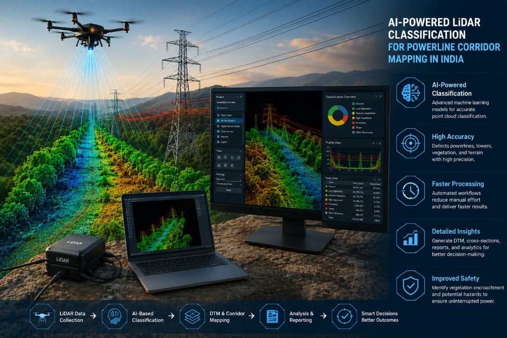
AI-powered LiDAR classification is transforming the way powerline corridors are surveyed, mapped and analysed. As electricity networks expand across cities, rural areas, forests and challenging terrain, utility companies need accurate geospatial information to manage transmission infrastructure safely and efficiently. By combining Artificial Intelligence (AI), LiDAR Mapping and GIS technology, organisations can process large volumes of point-cloud data and identify critical features such as powerlines, transmission towers, vegetation, buildings and ground points.
At MAPe IT Solutions, we provide advanced LiDAR mapping, GIS mapping, drone survey, remote sensing, photogrammetry and utility mapping solutions in India. Our technology-driven approach helps infrastructure and utility organisations convert complex geospatial data into structured information that supports better planning, asset management and decision-making.
What Is AI-Powered LiDAR Classification?
LiDAR (Light Detection and Ranging) is a remote sensing technology that uses laser pulses to capture detailed three-dimensional information about the Earth's surface and objects above it.
A LiDAR survey of a powerline corridor can generate millions of individual points, known as a LiDAR point cloud. These points represent different objects within the surveyed area, including:
- Powerlines and conductors
- Transmission towers and poles
- Trees and vegetation
- Buildings and structures
- Roads and terrain
- Ground points
- Noise and outliers
The challenge is converting this raw dataset into useful information.
LiDAR classification involves assigning point-cloud data to specific categories. When AI-assisted processing is introduced, repetitive classification tasks can be streamlined, allowing large datasets to be processed more efficiently while still requiring professional quality control and validation.
Why Powerline Corridor Mapping Matters
Powerline corridors can extend across hundreds of kilometres and pass through diverse environments. Regular monitoring is essential for maintaining infrastructure, identifying potential obstructions and supporting safe electricity transmission.
Traditional field surveys and inspections can be labour-intensive, particularly when infrastructure is located in difficult-to-access terrain.
Powerline corridor mapping using LiDAR provides a detailed three-dimensional view of the transmission corridor. This can help project teams understand the relationship between conductors, towers, vegetation, terrain and surrounding structures.
For utility companies and infrastructure organisations, this information can support:
- Corridor planning
- Asset inventory
- Vegetation assessment
- Infrastructure monitoring
- Maintenance planning
- GIS database development
- Engineering analysis
How AI + LiDAR Improves Powerline Mapping
The combination of AI and LiDAR introduces a more intelligent approach to processing large point-cloud datasets.
1. Powerline and Conductor Classification
One of the most important applications is the identification of powerlines and conductors within a LiDAR point cloud.
Accurately classified conductor data can help professionals understand the location and geometry of transmission infrastructure and integrate the information into GIS and engineering workflows.
2. Transmission Tower and Pole Identification
Transmission towers and poles can be classified from LiDAR data to create structured infrastructure inventories.
This can be useful for organisations managing large networks where maintaining an accurate spatial record of assets is essential.
3. Vegetation and Tree Encroachment Analysis
Vegetation growing near powerline corridors requires careful monitoring.
LiDAR vegetation analysis provides three-dimensional information about trees and vegetation surrounding transmission infrastructure. This can help identify areas that may require further inspection for clearance and maintenance planning.
Unlike conventional two-dimensional imagery, LiDAR can provide valuable height information, making it particularly useful for understanding the vertical relationship between vegetation and infrastructure.
4. Buildings and Structures
Buildings and other structures located within or close to powerline corridors can also be identified and classified.
This information can support corridor planning, infrastructure assessment and spatial analysis.
5. Ground and Non-Ground Classification
Separating ground points from non-ground points is a fundamental stage of LiDAR processing.
Accurate ground classification can support the generation of terrain models and improve subsequent GIS analysis. It also helps distinguish natural terrain from structures and other above-ground features.
6. Noise and Outlier Detection
Raw LiDAR datasets may contain unwanted points or outliers.
AI-assisted processing can help identify and remove inappropriate data, improving the overall quality and usability of the point cloud.
Professional quality assurance remains important because automated processing should be validated against project specifications and expected deliverables.
Looking for AI-Powered LiDAR Classification & Powerline Corridor Mapping in India?
MAPe IT Solutions delivers high-accuracy LiDAR mapping, drone surveys, GIS solutions, and geospatial data processing services for powerline corridors and infrastructure projects across India.
Call Now: +91 9443338087
Email: info@mapeitsolutions.com / ganesh.babu@mapeitsolutions.com
Key Benefits of AI-Powered LiDAR Classification
The integration of AI into LiDAR processing offers several advantages for large-scale infrastructure projects.
Faster LiDAR Data Processing
Large powerline corridors can produce extremely high volumes of point-cloud data. AI-assisted LiDAR processing can streamline repetitive classification workflows and help teams manage large datasets more efficiently.
Reduced Manual Effort
Traditional point-cloud classification can involve significant manual work. Intelligent workflows can reduce repetitive tasks, allowing skilled professionals to focus more on validation, analysis and project-specific requirements.
Consistent Classification
A structured classification workflow can improve consistency when processing large datasets covering extensive geographic areas.
Better Vegetation Analysis
Accurate 3D vegetation information can support powerline vegetation management, corridor assessment and maintenance planning.
Improved Asset Management
Classified LiDAR data can be integrated with GIS databases to create more useful spatial inventories of towers, conductors, vegetation and other corridor features.
Scalable Geospatial Workflows
The combination of AI, LiDAR and GIS can be particularly valuable for large infrastructure networks where processing requirements extend across extensive areas.
AI-Powered LiDAR Applications Beyond Powerlines
Although powerline corridor mapping is a major application, AI-powered LiDAR classification has wider applications across the geospatial and engineering sectors.
These include:
- Utility mapping
- Transmission infrastructure mapping
- Vegetation monitoring
- Corridor inspection
- Terrain modelling
- Asset management
- Infrastructure planning
- Environmental assessment
- Construction monitoring
- Urban mapping
When combined with GIS Mapping Services, classified LiDAR data can become part of a broader spatial information system that supports planning, monitoring and decision-making.
Role of Drone Survey and GIS
Modern geospatial projects increasingly use multiple technologies rather than depending on a single data source.
Drone survey can capture high-resolution aerial imagery and generate detailed mapping products. LiDAR Survey can provide dense three-dimensional point clouds, while GIS can organise, analyse and visualise the resulting information.
At MAPe IT Solutions, these technologies can be integrated with Remote Sensing, Photogrammetry and Utility Mapping workflows depending on project requirements.
This integrated approach can provide organisations with a more complete understanding of their infrastructure and surrounding environment.
Why AI + LiDAR Skills Matter for Students and Professionals
The growing adoption of AI, LiDAR and GIS technology is creating new opportunities for students, surveyors, GIS professionals and engineers.
Professionals entering the geospatial industry increasingly need to understand not only software but also the complete workflow:
At MAPe IT Solutions, learners can develop practical knowledge through training areas such as LiDAR Processing, GIS, Drone Survey, Photogrammetry and Remote Sensing.
For students, these skills can provide a foundation for careers in surveying, infrastructure, utilities, mapping, engineering and geospatial technology.
For working professionals, upskilling in LiDAR processing and AI-assisted geospatial workflows can help them adapt to the industry's growing use of automation and advanced data processing.
The Future of Powerline Corridor Mapping
The future of infrastructure mapping is becoming increasingly digital.
The integration of AI + LiDAR + GIS + Drone Technology can help organisations move from conventional manual workflows towards more structured, scalable and data-driven processes.
For power utilities and infrastructure companies, accurate geospatial information can support better corridor planning, vegetation assessment, infrastructure inventories and maintenance strategies.
The objective is not simply to collect more data. The real value comes from transforming that data into information that professionals can understand and use.
Choose MAPe IT Solutions for Advanced Geospatial Solutions
At MAPe IT Solutions, we combine expertise in LiDAR Mapping, AI-assisted classification, GIS, Drone Survey, Remote Sensing, Photogrammetry and Utility Mapping to support complex geospatial and engineering requirements.
Our solutions are designed for infrastructure companies, utility organisations, engineering consultants, government projects and other sectors that depend on accurate spatial information.
Whether you require powerline corridor mapping in India, LiDAR data processing, vegetation analysis, utility mapping or GIS integration, a professionally managed geospatial workflow can help turn complex datasets into actionable project information.
AI-powered LiDAR classification represents an important development in modern geospatial technology. By combining high-density LiDAR data with intelligent classification workflows, organisations can analyse powerline corridors more efficiently and gain valuable information about infrastructure, vegetation, terrain and surrounding features.
For businesses, this can support better asset management and infrastructure planning. For students and working professionals, it opens new opportunities to develop skills in one of the rapidly evolving areas of engineering and geospatial technology.
AI + LiDAR is helping build a smarter future for powerline mapping, infrastructure management and geospatial intelligence in India.
Contact MAPe IT Solutions
Reach out to our expert team for LiDAR classification, drone surveys, GIS mapping, and powerline corridor mapping solutions.
Phone: +91 94433 38087
Email: info@mapeitsolutions.com | ganesh.babu@mapeitsolutions.com