At MAPe IT Solutions, we provide high-accuracy LiDAR (Light Detection And Ranging) data processing services for a wide range of industries and applications. Based in Chennai, India, we serve clients across the globe with fast, reliable, and cost-effective LiDAR processing solutions that transform raw point cloud data into actionable geospatial intelligence.
LiDAR is a cutting-edge remote sensing technology that uses laser pulses to measure distances and generate highly accurate three-dimensional representations of the Earth's surface. Whether collected from airborne platforms, UAV drones, or mobile mapping vehicles, LiDAR data requires expert processing to deliver meaningful outputs for surveying, engineering, environmental, and infrastructure projects.
Our experienced geospatial team delivers precise Digital Elevation Models (DEM), Digital Terrain Models (DTM), contour maps, point cloud classifications, and much more — all produced to the highest quality standards and delivered on time.
MAPe IT Solutions offers LiDAR data processing outsourcing services to clients worldwide, including the USA, UK, Middle East, Australia, and across Asia. Our international clients rely on us for accurate results, competitive pricing, and seamless offshore collaboration.
- High-density point cloud processing with precision classification
- Fast turnaround for large-volume LiDAR datasets
- Cost-effective offshore processing solutions
- Deliverables in multiple formats: LAS, LAZ, ASCII, ESRI, CAD
- Experience with airborne, mobile, and UAV LiDAR systems
LiDAR scanning can be conducted day or night under clear flying or driving conditions, and our processing capabilities cover the full spectrum — from raw flight line data to final classified point clouds and derived products.
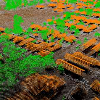
We classify raw point clouds into meaningful categories — ground, vegetation, buildings, water bodies, and more — enabling accurate bare earth extraction and terrain analysis.
- Bare earth and non-ground classification
- Utility classification (power lines, poles)
- Bathymetry classification (underwater terrain)
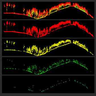
- Vegetation and canopy height modeling
- Building footprint extraction
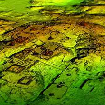
We generate high-resolution DEMs and DTMs from classified LiDAR point clouds, providing accurate representations of both the bare earth surface and the surface including features such as vegetation and structures.
- Bare earth DTM generation
- Digital Surface Model (DSM) production
- Elevation maps and hillshade models
- Hydrologically conditioned DEMs for flood modeling
We generate accurate contour lines from LiDAR-derived terrain models, suitable for engineering design, urban planning, and environmental assessments.
- Contour generation at custom intervals
- Smooth contour editing and quality checking
- Export in DWG, DXF, SHP, and other formats
Our 3D modeling and volumetric services are widely used in mining, construction, and quarrying industries where accurate volume calculations are critical for project planning and cost management.
- 3D terrain and surface modeling
- Stockpile and cut/fill volume calculations
- Building extraction and 3D reconstruction
- Change detection and deformation monitoring
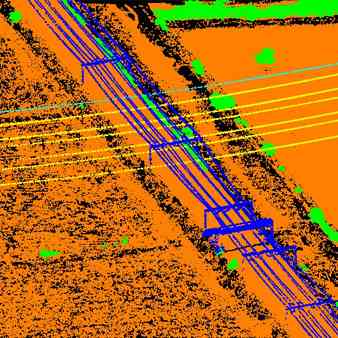
We specialize in the processing of LiDAR data collected along linear infrastructure corridors, including power transmission lines, railways, roads, and pipelines.
- Transmission line and pylon extraction
- Vegetation encroachment analysis
- Ground clearance and sag calculations
- Railway and road corridor mapping
LiDAR-derived terrain models are one of the most accurate inputs for flood modeling and hydrological analysis. We produce high-quality flood plain maps and drainage models that support disaster risk management and urban planning.
- Flood plain delineation
- Drainage network extraction
- Hydrologically conditioned terrain models
- Flood risk zone mapping
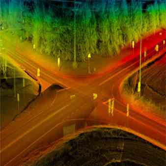
Mobile LiDAR systems mounted on vehicles or boats collect high-density point clouds of roads, streetscapes, riverbanks, and urban environments at ground level. We process this data into accurate 3D models for transportation, utilities, and smart city applications.
- Road and highway asset mapping
- Urban streetscape modeling
- Bridge and infrastructure inspection
- Utility corridor mapping at ground level
We integrate LiDAR point cloud data with digital orthophotos and hyperspectral imagery to produce enhanced geospatial datasets that combine elevation accuracy with rich spectral information — ideal for vegetation analysis, land cover mapping, and environmental monitoring.
- Forestry& Environmental Management
- Mining & Quarrying
- Oil & Gas
- Railways & Transportation
- Telecom & Utilities
- Urban Planning & Smart Cities
- Flood Risk & Water Management
- Infrastructure & Construction
Unmatched Accuracy — LiDAR delivers centimeter-level precision, ensuring your terrain models and maps are reliable for engineering-grade applications.
High-Speed Data Collection — LiDAR captures dense point clouds rapidly, covering large areas faster than traditional ground survey methods.
Day & Night Capability — LiDAR sensors operate independently of sunlight, enabling data collection under varied conditions.
Cost-Effective Outsourcing — Our offshore processing model significantly reduces the cost of LiDAR data processing without compromising quality.
Multiple Output Formats — We deliver in LAS, LAZ, ASCII, SHP, DWG, GeoTIFF, and other formats to suit your workflow.
Experienced Geospatial Team — Our specialists have handled large-volume LiDAR datasets across diverse terrains and industries.
- Experienced geospatial and LiDAR processing specialists
- Proven delivery across 30+ countries worldwide
- Expertise in airborne, UAV, and mobile LiDAR systems
- Support for LAS, LAZ, ASCII, ESRI, and CAD output formats
- Rigorous quality assurance at every processing stage
- On-time delivery with competitive offshore pricing
- Integrated services combining LiDAR, GIS, CAD, and photogrammetry
With 500+ satisfied clients across industries, MAPe IT Solutions is a trusted name in geospatial data processing. Our end-to-end LiDAR services — from raw data ingestion through to final deliverables — ensure you receive accurate, ready-to-use outputs every time.
Call Now: +91 9443338087
Email:info@mapeitsolutions.com
LiDAR data processing involves converting raw point cloud data collected by LiDAR sensors into usable geospatial products such as DEMs, DTMs, contour maps, and classified point clouds. It includes filtering, classification, model generation, and output formatting.
We process data from airborne LiDAR systems, UAV/drone-mounted LiDAR sensors, and mobile LiDAR mapping platforms. We handle both single return and full waveform data.
We deliver outputs in LAS, LAZ, ASCII, ESRI Shapefile, GeoTIFF, DWG, DXF, and other formats based on client requirements.
Yes, we offer LiDAR data processing outsourcing services to clients worldwide, including the USA, UK, Middle East, Australia, and Europe.
LiDAR is used across forestry, mining, oil & gas, railways, telecom, urban planning, flood management, construction, and environmental monitoring industries.
Yes, our team has extensive experience handling large-area and high-density LiDAR datasets efficiently, with fast turnaround times even for complex projects.
Costs depend on the volume of data, the complexity of classification required, and the output formats needed. Contact us for a customized quote.