High resolution three-dimensional photographs of complicated environments and geometries are captured using lidar survey technology. Lidar technology provides a quick, dependable, precise, and effective approach to collect millions of data points. which are used in thorough 3D models or in-depth reconstructions. Lidar survey and 3D laser scanners are a flexible, precise solution that enables businesses to get data they couldn't previously get. By using this information, they may make better conclusions and save both time and money.
Lidar survey is more expensive than photogrammetry survey, but it can be used in both daylight and darkness. Nevertheless, photogrammetry is only useful in daylight. This is possible since Lidar and laser both produce intangible laser/radio waves. We offer our goal-oriented services across India.
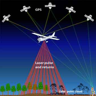
LiDAR Survey (Airborne Aerial Lidar)
Airborne Aerial Lidar [ Geospatial Technology 3D Mapping ]
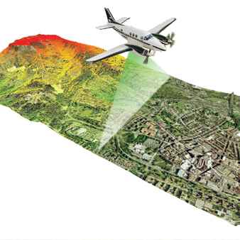
We deal with mobile and airborne Lidar survey technology, where a Lidar camera is mounted on a mobile vehicle or a UAV drone. This provides the Point Cloud data needed to create the object's 3D picture, orthophoto, LIDAR map, DTM, DEM, and DSM. which are also utilised for terrain mapping, urban planning, and forest management.
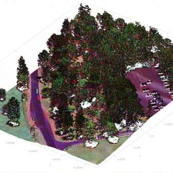
To determine the precise horizontal and vertical location of all existing elements on the site, MAPe It Solutions, a professional geodetic engineer, conducts an airborne LIDAR survey. A Lidar Point Cloud was created using data that was collected across an area of around 130 to 150 hectares. It took around two hours of Lidar 3D Mapping in the air to complete what would typically take three 2-3 months of conventional survey work in the field.