At MAPe IT Solutions, we provide high-accuracy ortho photo mapping and orthophoto processing services for surveying, engineering, urban planning, and environmental applications. Based in Chennai, India, we serve clients across the globe with precise, geometrically corrected aerial imagery that forms the foundation of reliable geospatial analysis and mapping projects.
An orthophoto is a geometrically corrected aerial or satellite image in which distortions caused by terrain relief, camera tilt, and lens characteristics have been removed. Unlike raw aerial photographs, orthophotos have a uniform scale and can be used as a map — allowing accurate measurement of distances, areas, and positions directly from the image.
MAPe IT Solutions uses the Leica Photogrammetric Suite and industry-leading software platforms to produce high-resolution orthoimages that meet the most demanding accuracy and quality standards. Our orthophoto production services include the complete workflow from raw aerial imagery through to final mosaicked, color-balanced, and tiled deliverables ready for use in GIS, CAD, or mapping systems.
MAPe IT Solutions delivers ortho photo mapping and orthophoto processing services to clients worldwide, including the USA, UK, Middle East, Australia, and across Asia. Our international clients rely on us for geometrically precise imagery, competitive pricing, and fast project turnaround.
Our global clients trust us for:
- High-resolution orthophoto production to client specifications
- Accurate orthorectification using ground control points
- Seamless ortho-mosaicking across large project areas
- Color balancing and radiometric correction for visual consistency
- Deliverables compatible with GIS, CAD, and web mapping platforms
With proven experience across large-scale orthophoto projects in diverse terrains and environments, we are a trusted outsourcing partner for surveying firms, government agencies, and mapping companies worldwide.
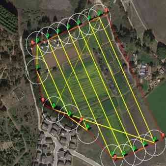
Orthorectification is the core process of removing geometric distortions from aerial and satellite imagery caused by terrain relief, camera tilt, and sensor geometry. At MAPe IT Solutions, we use camera and satellite models in conjunction with ground control points (GCPs) and elevation data to produce accurate, map-oriented imagery.
- Aerial photograph orthorectification
- Satellite image orthorectification
- UAV/drone image orthorectification
- Georeferencing and coordinate system alignment
- GCP-based precision correction
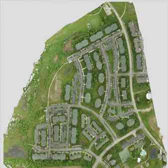
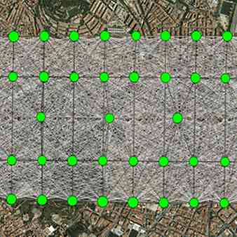
After individual images are orthorectified, we seamlessly stitch them together into a continuous orthomosaic covering the entire project area. Our mosaicking process ensures consistent radiometry and clean transitions across image boundaries.
- Seamless mosaic generation across large areas
- Overlap handling and blending
- Tie point generation and block adjustment
- Multi-spectral and RGB mosaic production
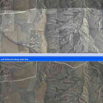
Variations in lighting conditions, sensor calibration, and atmospheric effects can create visual inconsistencies across an orthomosaic. Our color balancing and radiometric correction services ensure a visually consistent, professionally presented final product.
- Radiometric normalization across flight strips
- Color and tone balancing between adjacent images
- Haze and atmospheric correction
- Shadow reduction and histogram matching
Seam lines are the boundaries where overlapping images are merged in a mosaic. Poorly placed seam lines can cause visible artifacts, ghosting, or double features — especially in urban areas with tall buildings. Our seam line editing service ensures clean, artefact-free mosaics.
- Manual and automated seam line placement
- Building and infrastructure-aware seam routing
- Artefact and ghosting removal
- Quality inspection and final output verification
Large orthomosaics are tiled into standardized grid cells for efficient storage, distribution, and use in GIS and web mapping applications. We prepare tiles to any required grid specification and output format.
- Tile generation to client grid specifications
- Output in GeoTIFF, ECW, JPEG2000, MrSID, and other formats
- Pyramid layer generation for efficient rendering
- Metadata and spatial reference file creation
- RGB (True Colour) Orthophotography
- CIR (Colour Infrared) Orthophotography
- Black & White Orthophotography
- Thermal Imagery Processing
- Multi-spectral and Hyperspectral Imagery
- Urban planning and land use mapping
- Agricultural monitoring and crop health assessment
- Infrastructure corridor mapping (roads, railways, pipelines)
- Forestry and environmental monitoring
- Flood plain and disaster risk mapping
- Cadastral and land boundary mapping
- Construction site progress monitoring
- Smart city and municipal mapping projects
- Urban Planning & Smart Cities
- Agriculture & Forestry
- Railways & Transportation
- Telecom & Utilities
- Construction & Infrastructure
- Environmental & Water Management
Geometric Accuracy — Our orthorectification process removes distortions, delivering imagery that can be used as an accurate base map for measurement and analysis.
True-to-Scale Imagery — Orthophotos allow precise calculation of planimetric distances, areas, and positions, providing a real-life representation of ground features.
High Visual Quality — Our color balancing and seam line editing produce visually seamless, professional-grade orthomosaics.
Versatile Outputs — Deliverables are compatible with all major GIS, CAD, and remote sensing platforms.
Cost-Effective Outsourcing — Reduce processing costs significantly with our offshore orthophoto processing model.
Fast Turnaround — Our experienced team handles large project areas efficiently, ensuring timely delivery without compromising accuracy.
- Industry-leading Leica Photogrammetric Suite for orthoimage production
- Experienced photogrammetry and remote sensing specialists
- End-to-end processing from raw imagery to final tiled deliverables
- Multi-sensor capability: aerial, satellite, UAV, and mobile platforms
- Proven delivery across 30+ countries worldwide
- Strict quality assurance at every processing stage
- Integrated services combining orthophotos with GIS, LiDAR, and CAD workflows
- 500+ satisfied clients across government, engineering, and private sectors
MAPe IT Solutions combines technical excellence with a deep understanding of client requirements to deliver orthophoto products that are accurate, visually consistent, and ready to use in your projects. Whether you need a single orthoimage or a large-scale national mapping deliverable, we have the expertise and capacity to deliver.
Call Now: +91 9443338087
Email:info@mapeitsolutions.com
Ortho photo mapping is the process of producing geometrically corrected aerial or satellite imagery — called orthophotos — from which accurate measurements of distances, areas, and positions can be made. Unlike raw aerial photos, orthophotos are free from distortions caused by terrain relief and camera tilt.
Orthorectification is the process of removing geometric distortions from aerial or satellite imagery using elevation data and ground control points. The result is a map-accurate image that can be used as a reliable base layer in GIS or mapping systems.
An orthomosaic is a large, seamlessly stitched image composed of multiple orthorectified aerial photographs covering a project area. It combines the accuracy of a map with the visual detail of a photograph.
We process RGB, CIR, black and white, thermal, and multi-spectral aerial and satellite imagery from a wide range of sensor types including aerial cameras, UAV/drone sensors, and satellite platforms.
We deliver orthophotos and orthomosaics in GeoTIFF, ECW, JPEG2000, MrSID, and other formats, tiled and prepared to client specifications.
Yes, we offer ortho photo mapping and orthophoto processing outsourcing services to clients worldwide, including the USA, UK, Middle East, Australia, and Europe.
Costs depend on the project area, image resolution, number of images, and specific processing requirements. Contact us for a customized quote.